Te Taiao Environment
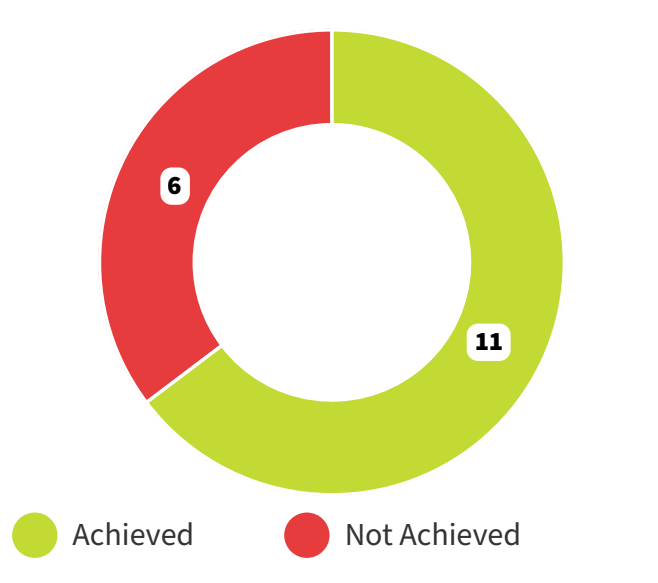
Greater Wellington’s Environment activities achieved 65 percent of their 17 performance measures this year. Of the 6 measure not achieved, 1 measure was within 2 percent of the target.
 What we deliver for Te Taiao
We support the mauri (vital life-force energy) of our Region’s unique taiao, and recreation opportunities within it. This includes protecting and restoring our freshwater quality, wetlands, coasts, native biodiversity, harbours and marine areas, air quality, soil and ecosystem health. We carry out restoration planting and control pests in regional parks, important ecological sites, and across the wider landscape with positive outcomes for native biodiversity, climate resilience and community connection.
We monitor the state of our regional taiao, create and enforce rules to protect it from the harmful effects of development. We educate and advocate for its restoration, promote safe recreation and use of our regional parks and harbours, and protect significant parts of the region from flooding events. Much or our work is done alongside others, including mana whenua partners, territorial authorities, conservation organisations, volunteers, and private landowners.
Sixteen projects increase flood resilience in the region
Sixteen flood protection projects in the Wellington Region are underway following the release of $101m of Government co-funding committed in Budget 2024. Flood Resilience Tranche 1 (before the deluge) contract signed with Ministry of Business, Innovation and Employment (MBIE), bringing forward delivery of some capital works, particularly in the Wairarapa. This is good news for the safety of the community, reducing flood risk earlier than planned.
The programme will construct flood protection and erosion control infrastructure like stopbanks, rock walls and groynes. This programme commenced work in summer of 2025 and will continue over the next three years. All projects in the programme were designed with local hapū, iwi and landowners, generating employment opportunities for local whānau.
Wairarapa Moana Wetlands and Major Rivers Riparian Planting project closure
Ministry for the Environment (MfE) funding for the Wairarapa Moana Wetlands and Major Rivers Riparian Planting projects have come to an end and reporting is now underway to close off these two projects. Over the last five years the funding has contributed to nearly 400,000 native plants being planted and protected by more than 30km of fencing across South Wairarapa.
We have expanded Greater Wellington’s role across the Wairarapa Moana, enabling increased pest plant and animal control, citizen science and monitoring events, and school engagement. Over $50,000 has been distributed to community groups for restoration activities.
During the project, there has been a shift due to two treaty settlements acts being enacted and the establishment of the Wairarapa Moana Statutory Board. Officers are working with partners to establish new group tikanga and working relationships for the way forward.
Recloaking Papatūānuku – one of the biggest and most ambitious native planting projects in Aotearoa
Recloaking Papatūānuku was established in 2022 by Greater Wellington with a vision for long-term restoration; land that was grazed in regional parks and now lacking biodiversity will, over time, be covered in a vibrant green ‘cloak’ of native forest.
In September of 2024 Rimutaka Prison nursery had supplied Greater Wellington with more than 130,000 plants so far. The eco-sourced seeds grown from the prison are being returned to the land in a restorative cycle, are planted in our regional parks, where ecosystems need the most help such as restoring the former farmland Belmont Regional Park and Queen Elizabeth Park.
Greater Wellington planted around 320,000 plants for the 2024/25 financial year as part of Recloaking Papatūānuku, and the completion of the Te Horo wetland re-creation. Community groups and volunteers have also made this ambitious project possible.
Purchase of Gollan’s Valley Station
We have successfully purchased the Gollan’s Valley Station, 1,366-hectare block of land in the hills above Eastbourne. Through this purchase, we can protect the entirety of the Parangarahu Lakes catchment - a site of great importance to mana whenua, and a wetland complex of national significance.
This also means we are able to unite the northern and southern halves of East Harbour Regional Park, potentially providing for a huge expansion in recreation and tourism opportunities. The whole of the skyline on the eastern side of the harbour is now protected in public land.