-
Whareama Estuary: Intertidal sediment monitoring 2012/13
This report presents the findings of fine scale sediment monitoring at two intertidal sites in the Whareama Estuary, a 12km long tidal river estuary on the Wairarapa Coast. This…
There is no digital version of this document available, but you can get in touch with publications@gw.govt.nz to get a copy of the document.
alarm Published 11 Nov 2013 -
Hutt Estuary: Intertidal macroalgal monitoring 2012/13
This report presents the findings of macroalgal cover monitoring as a broad scale indicator of nutrient inputs undertaken in the Hutt Estuary in January 2013.
There is no digital version of this document available, but you can get in touch with publications@gw.govt.nz to get a copy of the document.
alarm Published 11 Nov 2013 -
Hutt Estuary: Intertidal sediment monitoring 2012/13
This report presents the findings of fine scale sediment monitoring at a single site in the Hutt Estuary. This monitoring was undertaken in January 2013 and included an assessment of…
alarm Published 11 Nov 2013 -
Waikanae Estuary: Intertidal sediment monitoring 2012/13
This report presents the findings of fine scale sediment monitoring at one site in the Waikanae River Estuary. This monitoring was undertaken in January 2013 and included assessments of sediment…
alarm Published 11 Nov 2013 -
Waikanae Estuary: Intertidal macroalgal monitoring 2012/13
This report presents the findings of intertidal macroalgal cover monitoring as a broad scale indicator of nutrient inputs within the Waikanae Estuary undertaken in January 2012
alarm Published 11 Nov 2013 -
Porirua Harbour: Sediment monitoring 2012/13
This report presents the findings of fine scale sediment monitoring at ten intertidal and nine subtidal sites within Porirua Harbour. This monitoring was undertaken in January 2013 and included…
alarm Published 11 Nov 2013 -
Porirua Harbour: Broad scale habitat mapping 2012/13
This report presents the findings of the second broad scale habitat mapping survey undertaken in January 2013, throughout the intertidal areas and terrestrial margin of Porirua Harbour. Broad scale…
alarm Published 01 Nov 2013 -
-
-
14 September 2013 to 14 October 2013
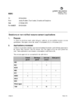
This document contains the decisions made under delegated authority on non-notified resource consent applications covering the period of 14 September to 14 October.
alarm Published 21 Oct 2013